Projects
Chippewa Township (2017)
Calvin Center for the Arts (2017)
Calvin Center for the Arts (2017)
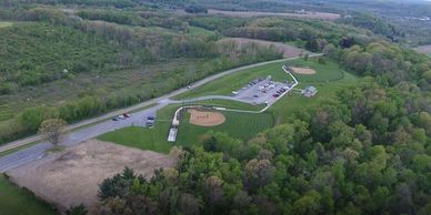
Created updated imagery and promotional video of the recently constructed ball fields at Veterans Park and the I.S. and Gertrude Sahli Nature Park.
Calvin Center for the Arts (2017)
Calvin Center for the Arts (2017)
Calvin Center for the Arts (2017)
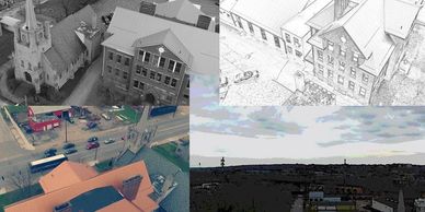
Created promotional videos for Transcending Space and Time Art Show in addition to videos for general promotion of the Calvin Center for the Arts.
Bike the GAP (2016)
Calvin Center for the Arts (2017)
Alaska LNG (2010-2016)*
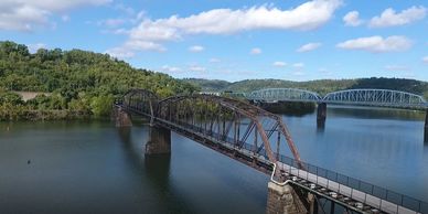
Flew aerial video along the Great Allegheny Passage (GAP) Bike trail for use in Bike the GAP promotional material.
Alaska LNG (2010-2016)*
Alaska LNG (2010-2016)*
Alaska LNG (2010-2016)*
Cultural GIS Lead on 6 year large scale (800+ mile) Alaska LNG project. Developed geodatabase, field data collection and QAQC methodologies, logistics implementation for remote access along with tracking progress along the way.
*NHG Alaska, LLC, Northern Land Use Research, Northern Land Use Research, Alaska, and Gray & Pape, Inc.
TEUI (2006-2007)*
Alaska LNG (2010-2016)*
TEUI (2006-2007)*
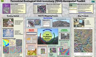
Geospatial Trainer and Developer for the Terrestrial Ecological Unit Inventory program at the USFS Remote Sensing Applications Center. Developed training material and developed the Connotative Legend Tool.
*Red Castle Resources, LLC
AGPPT (2001)*
Alaska LNG (2010-2016)*
TEUI (2006-2007)*
Lead GIS/GPS Specialist for the URS Anchorage office on the 750+ mile Alaska Gas Producers Pipeline Team project. Organized data, trained field crews, accompanied field crews, developed remote data viewing procedures, post-processed data and created graphics.
*URS Corporation